Inspiration
Is Sundance’s new platform the future of resort trail maps?


BLANCHARD
Maps.
I’ve covered them dozens of times over the 15 years I’ve been writing on SlopeFillers. I even dedicated an entire week to maps just to keep up with all the various concepts that were rolling out from startups and agencies alike.
Yet, all these years later, the primarily method of showcasing a resort remains the classic flat, 2D design with the hand-painted variety still as popular as ever.
After that surge of map innovation about 5-7 years ago, it’s been fairly quiet on this front.
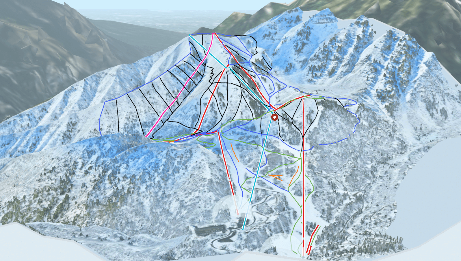
Until this week when Sundance unveiled their new map.
A few months ago I got in touch with Larry Dalton from Rock Garden, the folks behind a map product called Legend Guide. Larry gave me a demo and walked me through how the tech works and tries to overcome hurdles faced with past attempts at 3D maps.
For example, instead of relying on satellite footage that may have been captured during a less-than-optimal time of the season, they choose a photoshoot-worthy day mid-season to fly drones that capture high resolution imagery they can overlay onto their 3D model. But even that footage doesn’t always give the best renderings of things like buildings or lift terminals, so they actually have a layer of super high quality 3D imagery woven into the map just for key points of interest. And as you zoom in, the map swaps to this more detailed model.
Resorts are famous for wanting to be on the cutting edge, but not the bleeding edge, but that was exactly what Sundance’s Marketing Director, Nick Como, told me was a key reason for their decision to go with this platform.
We like to do things different and try new things at Sundance Mountain Resort. It’s in our DNA. When Rock Garden approached us to build a first-of-its-kind interactive map, we jumped at the chance. Our resort is surrounded by vast mountains, with Mount Timpanogos looming over the ski runs–something a paper map just can’t translate. Rock Garden’s ability to blend the coolest part of Google Earth and drone imagery into an interactive trail map is groundbreaking, and will help newcomers discover what makes Sundance Resort such a beautiful place to ski and ride.
A few months ago I talked about how Nick and his team were keeping it simple with their choice of print ad imagery and going big on one of their strongest assets, the views.
This is another big step in that really smart direction.
I also got in touch with Rock Garden’s CEO, Berk Frei, and he echoed that sentiment from Nick.
Our mission is to make exploration more immersive and accessible—to inspire adventures off the beaten path and help resorts like Sundance show what makes them so special. Sundance is the perfect place to kick things off: a resort tucked beneath one of Utah’s most iconic peaks, with terrain 2D maps just can’t do justice to. It’s the kind of place that deserves to be shown with real depth and detail—and that’s exactly what this tech was built for.
I’m really intrigued by this technology. I love the fact that you get an accurate, 3D view of the mountain. I love that the imagery is captured on a day with ideal conditions by high quality cameras. I love that key points have a higher fidelity version you can explore when you zoom. I love that you can do things like, say, fly down Marmot Gulch, the run where I got my first chance at first tracks as a teenager…
…but I think that flyover is a reminder that when you’re the first in line, it’s never going to be perfect. My slow, small-town internet connection couldn’t quite keep up with my flyover and give me the full experience.
And that’s okay, that’s part of being first.
It’s tempting to judge new tech by where they are today. And while that’s absolutely important, to me the key is to look at where they seem to be going. Rock Garden has built a foundation that gives them the opportunity to take this tech in a lot of really interesting directions that potentially allows the map to serve as much more of a central hub for content and exploration than I’ve ever seen before.
So, yes, the current state is super intriguing, but their direction?
That what excites me the most.
About Gregg & SlopeFillers
I've had more first-time visitors lately, so adding a quick "about" section. I started SlopeFillers in 2010
with the simple goal of sharing great resort marketing strategies. Today I run marketing for resort ecommerce and CRM provider
Inntopia,
my home mountain is the lovely Nordic Valley,
and my favorite marketing campaign remains the Ski Utah TV show that sold me on skiing as a kid in the 90s.
Get the weekly digest.
New stories, ideas, and jobs delivered to your inbox every Friday morning.
